
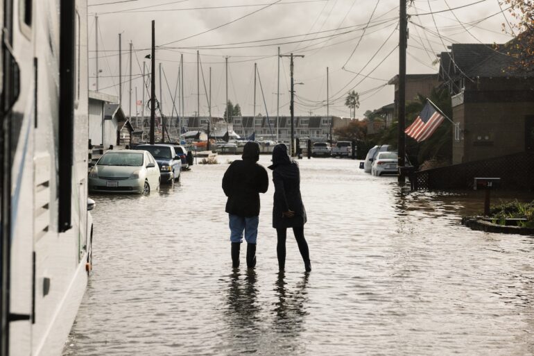
It’s already here: as of January 2026, Marin is suffering from the effects of king tides. Floodwaters seeped over what was previously considered high ground, flooding Corte Madera, Sausalito and San Rafael homes and businesses. King tide flooding reached a 28-year high, aided by strong winds.
Below, we examine how local organizations and communities are working to tackle this growing problem.
Have any photos of the recent flooding? Please submit you photos to editorial@marinmagazine.com or tag us on Facebook or Instagram @marinmagazine.com.
Preparing for Flooding
Near San Rafael Creek, two dads push their toddlers in swings, a bicyclist rides by and a woman walks her dog. For Marina Palma, it is a beautiful Saturday in the Canal community. And although it looks like everyone is on dry land, they are, in fact, in the bottom of a bowl, with their streets and homes sinking below the bay.

Palma, a longtime resident and advocate of her community, recently became a member of the San Rafael steering committee on sea level rise so that she can educate and prepare others. Many people don’t understand that the flooding already happening during high tides and storms is going to get worse.
“We are at risk of losing our homes, and our community would be destroyed,” Palma said. “Together we should make an effort to minimize the effects these floods could have.”
Now is the time for communities to get together throughout Marin County to discuss and strategize next steps to prepare for the rising sea.
“Right now, yards and people’s gardens are keeping the water out,” said Kate Hagemann, San Rafael city climate adaptation planner.“ The pumps are able to keep up but they aren’t designed to keep out the ocean.”
Expanding Ocean

The sea surrounding Marin on three sides is one of its most beautiful features. And yet, estimates predict that in 25 years the ocean will be about one foot higher than it is today.
But this isn’t a future problem. Anyone living east of 101 or biking the Mill Valley path or driving in Corte Madera knows Marin is flooding now.
The Transportation Authority of Marin has identified 19 areas of vulnerability in the county. Mikaela Hiatt, an associate planner at TAM, says they are looking at a timeline of solutions and options, recognizing that some roads, such as evacuation routes, may need attention sooner. “Raising a road 6 inches won’t allow for long-term protection but it could provide access in the near-term,” she said.
We’re all connected by roads, many of which are on the county’s bay side, said Anne Richman, TAM’s executive director. Keeping roads passable is a safety issue.
“An impasse or a failure in one area can affect people who don’t live nearby,” she said. “Even if you live further inland, your ability to get around will be impacted.”
More Water Is Coming

Predicting how high the water will rise or when is less important than preparing, according to Chris Choo, assistant director of the Marin County Community Development Agency. “We need to plan for that water — whether it comes as storm surge or king tides or sea level rise.”
Planning for what some perceive as a “long-term emergency” is hard, Choo said, but it’s been getting easier. “When you see water rising and rising, waves crashing against your home… it’s humbling and frightening,” she said. “It hits at a gut level.”
Marin County Supervisor Stephanie Moulton-Peters agrees. “No one should be surprised about this anymore,” she said, and our changing climate “is an invitation to co-create the future.”
Planning Now

Over the next months, Marin residents will be invited to workshops to provide ideas and feedback on how to manage flooding and higher seas. Leaders are working to comply with California Senate Bill 272, which directs the nine Bay Area counties to submit shoreline adaptation plans to the Bay Conservation and Development Commission.
Fortunately, Marin has a 10-year head start. The groundwork was laid by former Supervisor Kate Sears, who advocated for living with water sustainably, and Jack Liebster, who won a grant in 2015 for a two-year study to assess the county’s vulnerability to sea level rise. Choo managed that project, culminating in BayWAVE, an interactive map showing where water might flow at different levels and what was in the water’s way.
Early on, to help people imagine the future depth of water, Leslie Alden, at the time Sears’ aide, helped place custom viewfinders along the multiuse path in Mill Valley. When people looked through the viewfinders, they could see their current surroundings and then, with a push of a button, the same landscape covered in 3 feet of water.
“You have to show people,” said Alden, now executive director of Act Now Bay Area. “When they have an immersive experience, they see it for themselves.”
Drawing The Line

Once people understand Marin’s shorelines are on the move, a first step is to decide where to define the “resilient edge,” the line between land and water. On one side could be marshes and reefs and perhaps floating shops or parking barges. On the other side, buildings and roads could be elevated.
And, of course, all of these adaptation solutions are expensive.
At a January workshop in Sausalito, Matthijs Bouw, a Dutch architect and founder of One Architecture, emphasized that by working together, communities can pool resources to create shared benefits, like parks and ponds that hold stormwater runoff. “It’s more cohesive and cost-efficient but requires buy-in and coordination,” he said.
Participants at that meeting commented on different proposals and possible solutions. “I’m quite impressed by what’s being done with floating communities abroad and in New York City,” said Felicity Gordon, a designer and longtime houseboat resident. Despite misgivings about enlarging the number of floating homes, she enjoyed the workshop and was happy to be part of the discussion regarding her community. “I’m thrilled to see that there’s a long-term approach to addressing sea level rise.”
Protecting Community

One of the guidelines from SB 272 is to prioritize underserved communities first. With the relationships they’ve built, the county is ready. “We have the ability to apply the equity lens, because we see the whole picture,” said Ariel Espiritu-Santo, assistant county executive. “That’s how we can help. We’re better when we’re together.”
And, she added, “Sea level rise doesn’t know jurisdictional boundaries.”
The Marin Climate Justice Collaborative, a newly formed group that unites leaders from the Canal and Marin City, is making sure their vision is incorporated into plans: more green spaces, more affordable housing, better transit connections.
The challenge is to protect these communities without displacing the residents. With a large population of renters, gentrification is a concern. “The housing crisis is not separate from the climate crisis,” said Carly Finkle, senior policy manager of Canal Alliance.
The key is listening to the people who live in each community, Palma said. She encourages decisionmakers to get to know the residents of the Canal. “Let’s do what we need to do now so we can stay,” she added. “Our kids were born here and we want them to go to school here. We are Marin.”
Making Your Voice Heard
Individuals can shape how Marin adapts. Janelle Kellman, founder of the Center for Sea Rise Solutions, first became involved in Sausalito as a volunteer on the planning commission. “I saw a very real problem,” she said. “I wanted to get to the bottom of why Sausalito is flooding.”
In 2020, after getting elected to the city council, Kellman started a sea level rise task force. She’s helped win $2 million in funding, which made it possible for Sausalito to study its vulnerability.
Kellman, who is running for lieutenant governor in 2026, added, “If people see the power of local action, with real outcomes, I hope it will inspire them to say, ‘Hell yeah, that’s where I want to make a difference.'”
Adapting our Habitat to Live With Sea Level Rise
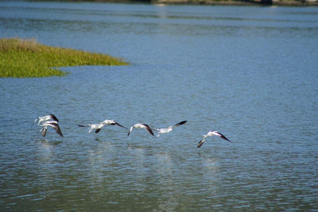
In Marin, driving along the 101, it’s not surprising to glance out the window and spy a great blue heron fishing or a black-necked stilt wading through eelgrass. They are reminders that our coastline was once mostly tidal marshes.
For centuries, we’ve reclaimed wetlands for development. “When you look at what’s been filled — all the way from the hills to the bay, well…” said Barbara Salzman, president of the Marin Audubon Society. “It’s important to keep the little pieces we have left.”
Ironically, climate change is stepping in to determine the fate of Marin’s marshes, too. One foot higher oceans, which may occur as soon as 2050, could restore wetlands to historic levels of the 1850s. And as the sea rises, stronger waves will change the shore edge, driving animals and plant species inland. And if we don’t make room, our natural world will degrade further.
That’s why county leaders and planners agree that the threat of sea level rise is an opportunity to improve our coastal environment.
Adapting To Higher Seas

What will be dry land and what will be marsh? A first adaptation step is deciding where to draw the “resilient edge,” the line between land and water. Then it’s a question of how the changes under consideration will affect the habitat. “You have to weave together a lot of different things,” said Chris Choo, assistant director of the Marin County Community Development Agency. “We have to map a way forward.”
Planners agree on four main adaptation strategies: raising buildings and infrastructure like roads; hardening the edge where water encroaches on development; reducing the impact of wave action with nature-based solutions; and floating architecture where there’s no way to avoid the incoming sea.
Two of the strategies — elevating and floating homes and buildings — already exist in Marin. Many structures are on pilings in tidal communities. The Sausalito houseboat marinas have raised parking lots, and the newest dock rises and falls with the tides, keeping utilities safe from saltwater.
Hardening the land-water edge usually involves building a seawall, a solution that’s often chosen when there isn’t much space. “A wetland can’t be just plopped down,” Choo said, adding that in an urban area like San Rafael there isn’t room for a sloping marsh.
But seawalls disturb where the water goes, and marine life experience what’s called a “coastal squeeze,” losing places to feed and spawn and thrive.
Instead, there’s good science to back green solutions.
Bringing Back Oysters

“Oyster reefs are just as effective, if not more, as those highly engineered solutions we often see, like riprap and seawalls,” said Katharyn Boyer, professor at San Francisco State and director of the Estuary and Ocean Science Center. “And, they provide habitat.”
Oysters are the heroes of the sea. Olympia oysters slow erosion by catching sediment and filtering out pollutants as they feed, such as those that cause algal blooms. One oyster purifies eight to 12 gallons of water per day. Female oysters disperse fertilized oysters in a plankton-like form, which swims around for two weeks, then settles on sheltered estuaries, which is why it’s vital to provide reefs in tidal zones.
In 2012, Boyer, an expert in the restoration and conservation of coastal habitats in a changing climate, led the first Living Shorelines Project in San Rafael at Spinnaker Point. Her team created a series of manmade oyster reefs with and without eelgrass plantings. They used shell bag mounds to see if these reefs would attract oysters, reduce the flow of water and accumulate sediment.
“It was wildly successful — there are millions of oysters out there,” she said, noting that despite flaws in the design, the reefs did accumulate sediment and slow wave action.
Building on that first success, they built new modular and more lightweight reefs. In 2020, they installed them in three areas in Marin: in the same location in San Rafael; at the north end of the Estuary and Ocean Science Center, between Tiburon and Corte Madera; and at Dunphy Park, in Sausalito.
All three succeeded, with especially ideal conditions in Sausalito. “The biggest Olympia oysters anyone has seen are at Dunphy Park,” Boyer said. They have found individual oysters in the 40–50 millimeter range (1.5–2 inches). That’s about 10 millimeters larger than what’s normally found in San Francisco Bay.
Restoring Marshes

It turns out the protected shoreward sides of oyster reefs are also ideal for eelgrass. Eelgrass, a native flowering plant, forms beds above ground and their rhizomes help keep sediment in place. They provide essential spawning space for herring and other fish as well as benefits for the planet.
“Eelgrass is a climate powerhouse,” Boyer said. “They capture carbon and they can raise the pH of the water to counter the acidification of the ocean.” More acidic oceans are bad news for shellfish, and their decline would impact the whole ocean ecosystem.
Bothin Marsh in Mill Valley, stretching from Blithedale Avenue to Route One, is one place where bringing back a healthy wetland will encourage eelgrass growth. The multiuse path that divides the marsh is going to be moved to the perimeter, close to the shops and restaurants in Tam Junction. “We can give up a little and gain a lot,” Choo said. The restored 1200-acre marsh will be rebuilt to reduce flood risk and provide saltwater at the right depth for the plants to get sunlight and live. The terrain will become varied in height, enabling animals to hide at high tide from predators and rising water. The approved project is expected to be completed in 2030.
In San Rafael, the rehabilitation of Tiscornia Marsh is already underway. The Marin Audubon Society teamed up with the Multicultural Center of Marin with a grant from the Marin Community Foundation to fix this critical habitat near the Canal. “The existing marsh was eroding,” Salzman said. The project will open the diked marsh to tidal action, providing transition zone habitat for wildlife and flood control.
The Marin Audubon Society also worked to restore wetlands in Bahia near Novato. “The marsh was basically barren,” she said. “The most difficult part is dealing with the invasives.” Volunteers helped plant natives, which needed watering for a few summers until becoming established.
Living With Water

Supervisor Stephanie Moulton-Peters is optimistic that Marin will make choices that will simultaneously prepare the county for a higher sea and enhance the environment. “There are many examples of communities living with water,” she said. “People around the world have figured it out, and we can, too.”
We don’t need to look further than Larkspur to imagine a future where people and wildlife can co-exist. Near the ferry terminal, 48 homes rest on pilings above the tidal marsh.
Walking the half-mile Greenbrae Boardwalk to and from their car is not a problem for local Wanden Treanor and her partner. “It keeps us active, and it’s good for our mental health,” she said.
Although some of the homes will need to be raised higher, and safeguards need to be added to reduce wave action from the larger ferries, the community happily coexists with the snowy egrets and herons.
“We’ve lived here for four decades,” Treanor added. “It’s home.”
