
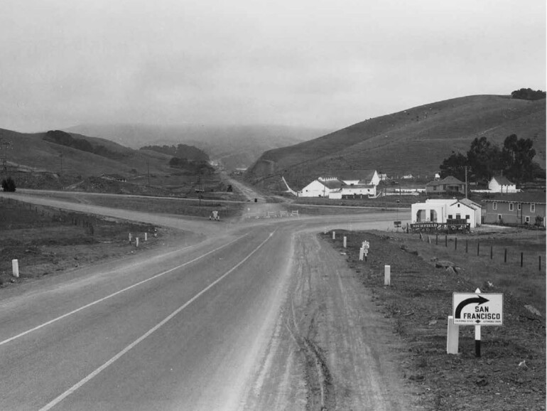
Can you pinpoint the location of this photograph? Three clues: 1. Nowadays, tens of thousands of people drive this route daily; it’s called Highway 101. 2. Those buildings on the right include Avila’s Richfield Gas Station, the Ruth Court Motel and Wilkins’ Dairy Farm. Final clue: Tiburon, Mill Valley, Strawberry and Tam Junction are involved in locating this photo. It was taken on June 6, 1930.
Answer: The camera taking this photo was facing south on today’s Highway 101. Note the small sign at lower right saying turn right for San Francisco. Essentially, that means you’d be traveling west on today’s East Blithedale Avenue (if you turn left, you’d be on today’s Tiburon Boulevard in Strawberry). Why? Because in 1930, not only was there no Golden Gate Bridge, there was also no Richardson Bay Bridge. So, to catch a Sausalito-San Francisco ferry from central and northern Marin County, you’d turn right on today’s E. Blithedale, then left on Camino Alto through Tam Junction before reaching Sausalito’s ferry terminal. Now look closely and in the middle of the photo you’ll see Highway 101 coming through a pass under construction. That’s because the original Richardson Bay Bridge was completed in 1931 making possible this more direct version of Highway 101. Then the Golden Gate Bridge opened in May of 1937. If you’re still having trouble locating this photo, the white buildings on the right include today’s Arco gas station, Public Storage and Goodman Building Supply.
