
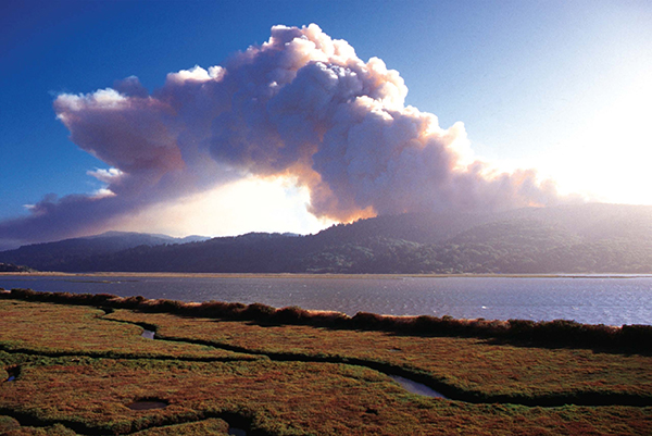
Stand almost anywhere in Point Reyes National Seashore and you’ll see where Marin County’s last disastrous wildfire began: on the slopes of Mount Vision, at 1,285 feet the park’s most dominant promontory. Here, on October 3, 1995, a campfire that had been inadvertently left smoldering by a group of teenage campers kindled back into flame and began to spread across the mountain’s slopes. The Mount Vision fire burned over the next 13 days. By the time it was contained it had consumed 12,000 acres and destroyed 45 homes. This is the most recent wildfire disaster in Marin County. It won’t be the last. In 2017, Marin, like the rest of California, like the rest of the American West, is more vulnerable to wildfires than ever before.
A STATE DESIGNED TO BURN

“California burns, and frequently conflagrates,” writes Stephen J. Pyne, dean of American fire historians, in his book California: A Fire Survey. “Not only do fires burn everywhere, but they can persist for weeks and can, from time to time, erupt into massive bursts or savage outbursts.”
Go to another Marin mountain, Mount Tamalpais, and you can begin to understand what Pyne means. Much of the mountain is covered with chaparral — a plant community that, as many have noted, gives Mount Tam its distinctive velvety texture when seen from a distance. Close up, chaparral is anything but velvety — one of its characteristics is prickliness — but it is still beautiful, especially in spring, when its ceanothus blooms in foamy purple and wildflowers like paintbrush and monkeyflower erupt in exclamation points of reds and oranges and yellows.
Along with prickliness, another chaparral characteristic is this: it has evolved to burn. Pyne notes that more than half the ecosystems in California are fire dependent, meaning they require regular wildfires to survive. No plant community displays that dependency more powerfully than chaparral. The traits, like the small, oily leaves that help chaparral plants survive California’s rainless summers, make them supremely vulnerable to wildfire. But they benefit from fire, too: the seeds of many chaparral plants need wildfires’ heat to germinate.
In, say, 1700 or 1850, chaparral mostly burned on its own, generally ignited by lightning strikes; some of California’s Native American tribes did employ what are now called controlled burns to clear ground for agriculture, but on a relatively small scale. As California entered the more populous and mechanized 20th century, the situation changed. Now human beings could start fires, easily — with campfires, car mufflers, arson. Those human-caused sources of ignition were the culprits behind Marin’s big 20th-century blazes, from the Mill Valley fire of 1929 to 1995’s Mount Vision fire.
In the 21st century, our wildfire situation has grown more dangerous still. One change comes from California’s continued population growth: from the Bay Area to the Gold Country to the Sierra Nevada, we’re building more homes in what fire professionals call the wildland-urban interface, meaning away from town, out in the forest, in the chaparral, lovely locations that easily ignite.
The other change is more global: California, like the rest of the West, like the world, is getting warmer. And it turns out that a warmer planet, a warmer state, means more wildfire.
“WE DIDN’T KNOW FOR SURE”
“People knew that something was going on with fire,” says LeRoy Westerling, associate professor at University of California, Merced, and co-director of the Sierra Nevada Research Institute. “But we didn’t know the full context of it. And we didn’t know for sure what was guiding it.”
Professor Westerling has been studying western wildfires for well over a decade. Like other fire researchers, he could see the trends. Average temperatures were rising — summer of 2016 was the hottest summer on record in California. And wildfires were getting worse. On federally managed forest lands in the West, the areas burned by wildfires each year had increased by 1,000 percent since the 1970s and early 1980s. Fire season was starting earlier in the spring and continuing later into the fall.
The challenge, Westerling explains, is that when you try to link wildfires firmly to climate change, you have to deal with a lot of variables: the increase in ignition sources (those power lines, those campfires), the increase in human population, more. It took awhile to prove how temperature was impacting Western fires. Now, he says, that proof exists. Last year he and other researchers published a scientific paper announcing that our new, more fire-prone West is clearly linked to warming temperatures.
The strongest evidence they cite is in higher-elevation forested regions like the Rocky Mountains and the Sierra Nevada. For a variety of reasons, the link is more subtle at lower elevations as in Marin. Still, Westerling says, “The longer we watch the process the more we see it showing up in different places.”
The experts at CAL FIRE — the state agency charged with fire protection and prevention — agree. Notes CAL FIRE Information Officer Lynne Tolmachoff, “Studies show that since the 1970s, the average length of fire season in the West has grown by 78 days. Fire behavior that was once called ‘unprecedented’ is now the normal.” She adds: “In California, we have historical fire data that dates back to the 1920s. Of the top 20 largest California wildfires, 13 have occurred since 2000, and five of those 13 in just the past four years.”
And over the last couple of years, lower-elevation portions of Northern California have suffered some truly disastrous fires. In 2015, the Butte Fire, in Amador County, burned 70,000 acres and 475 homes and killed two people. The Valley Fire, in Lake County, burned 76,000 acres, destroying nearly 2,000 structures, and killed four people. In 2016, the Soberanes Fire in Big Sur burned 132,000 acres and 57 homes.
“THIS IS NO JOKE. IT COULD REALLY HAPPEN. HERE.”
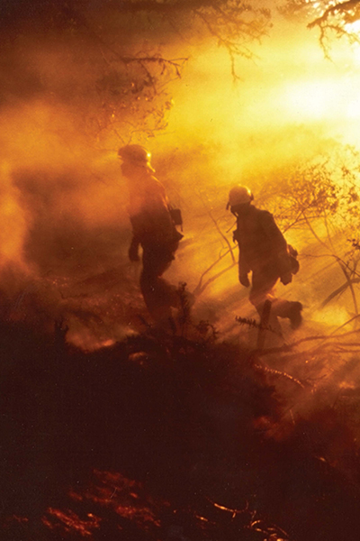
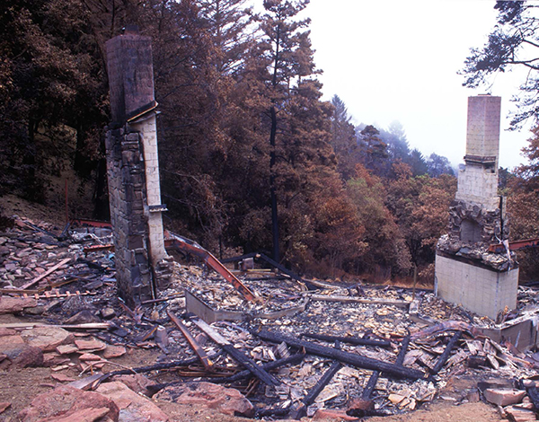
The Butte Fire, the Soberanes. The names of big California wildfires begin to sound like the names of Civil War battles, echoing with the same somber sense of tragedy. To see the aftermath of a big wildfire is to feel like you’ve stumbled onto a battlefield after the battle has been lost. Years ago, a Los Angeles County fire captain guided me through the burn zone of a wildfire that had incinerated much of Malibu, on the coast above Los Angeles. The hillside neighborhood had once been an expensive aerie of rambling homes, lush gardens and spectacular views down to the Pacific. Three weeks after the fire, only the views remained, the ocean glinting blue at the bottom of a steep, ash-gray slope. The houses were gone. Left behind were concrete foundations, blackened at the edges, random chimneys, maybe a scattering of charred yuccas. Also, curiously, stray blobs of metal that resembled bad public art. When you took a closer look at these they turned out to be the melted remnants of a water heater, a washer-dryer set, a Mercedes grille. A wildfire can burn at 1,400 degrees Fahrenheit. It doesn’t leave much.

Those are the stakes, then — what we don’t want to have happen in Marin. By virtue of its climate, topography and plant communities — those lovely hills covered with chaparral — the county is vulnerable. By virtue of this being the 21st century, it is more vulnerable than before.
Marin County fire professionals understand the heightened threat. Says Tom Welch, fire chief for Mill Valley — the community that in 1929 suffered Marin’s most famous fire: “Fire behavior has really gotten more extreme in the last couple of years. You see it in what we experienced in Lake County. Volatility has gone through the roof. The fires move exceptionally fast. And that can result in fatalities.”
Welch is experienced in the fire threat to Marin. He’s worked for the Mill Valley Fire Department since 2000 and has been chief since 2015. As a town laid out on a mountainside in the horse-and-buggy era, he says, Mill Valley gives firefighters particular challenges, notably streets too narrow and winding to easily steer fire engines along. “We buy the smallest engines we can find. And we really dial up on training people how to drive them here.”
He also says that his department and the other local and state and federal departments that make up Marin County’s patchwork quilt of fire agencies work well together to make the county more fire-safe. “We know that fire in one community can lead to a fire in the next. We work together doing things like creating fuel breaks to slow a fire down.” Especially promising, he says, is a new program being instituted this year: the Marin County Community Wildfire Protection Plan. “We took a really deep dive into fire modeling — we looked at hillside slope, vegetation, weather patterns. It lets us use almost microscopic precision to decide where to put in fuel brakes that will be effective.”
Another program he’s proud of: evacuation drills, where Mill Valley neighborhoods are invited to behave as if a fire was nearing their homes and leave for an evacuation center. “It helps build muscle memory for folks.” Welch’s personal must-do list: Clear brush around your home. Have a grab-and-go bag containing critical papers, credit cards, other essential items. Know multiple routes of evacuating your home by car, by bike, on foot.
Above all, he says, Marin County residents need to know that wildfires are a reality in their beautiful, flammable county. “It’s just human nature that if people haven’t seen it or felt it, touched it or tasted it, they don’t think it can happen. Fire is something people see on TV. I wish we had folks who were alive back in 1929 and experienced the Mill Valley Fire. They could tell people now, This is no joke. It really could happen. Here.”
THE MILL VALLEY FIRE OF 1929

It was called the Great Fire, like the Great War, which had finished 11 years earlier. The adjective gives a sense of the disaster’s magnitude. Shortly before Independence Day in 1929, a wildfire started that nearly erased Mill Valley from the face of the earth.
Trouble began early on the warm afternoon of July 2, on the flanks of Mount Tamalpais, near where the Mount Tamalpais Scenic Railway made a “double bow knot,” its tracks paralleling themselves four times to gain elevation. While the specific source of ignition remains a mystery — a spark from the train, a cigarette dropped by a passenger — what is known is that by 2 p.m. a column of smoke could be seen rising from the mountain.
The winds that afternoon were clocked at 35 miles per hour. The fire moved fast. Within minutes, flames were galloping down the mountain toward town. One story has it that the Mount Tam railway engineer drove his train downhill barely ahead of the fire, but had to keep the brakes on because the tracks were so slippery with snakes trying to flee the flames. Within hours, the fire had swept down Blithedale Canyon toward the heart of town, house after house exploding in flames on its way.
Mill Valley firefighters battled the fire and were soon joined by firefighters from neighboring towns. But it was weather that was Mill Valley’s salvation. On the evening of July 2 — at a point when the fire had spread to within 100 feet of city hall — the winds turned, pushing the fire back on itself. It continued to burn for three more days but did no further damage to homes.
In the end, the Mill Valley fire burned more than 2,500 acres and destroyed 117 homes. (It also brought the demise of the Mount Tamalpais Railway.) Today more than 1,100 houses stand within the fire’s footprint. The Mill Valley fire wasn’t the most devastating fire in 1920s Bay Area. That sad honor goes to the Berkeley fire of 1923, which destroyed 584 homes and resulted in two human deaths. But Mill Valley’s fire history is a reminder that even now the qualities that make Marin County so lovely — its chaparral-and-forest-covered ridges and canyons — make it vulnerable to disaster.

This article originally appeared in Marin Magazine’s print edition under the headline: “The Fire This Time“.
